
MRP: ₹700
₹619
₹ 81 Off
(Incl. of all taxes)
Qty
Buying in bulk?
In stock
Deliver to
- 7-day returns
- Secure payment
- International shipping
- Carefully packed
Get this at ₹ 588Extra 5% OffAdd items worth ₹999 to the cart & get extra 5% off
Get this at ₹ 557Extra 10% OffAdd items worth ₹1499 to the cart & get extra 10% off
Book Summary
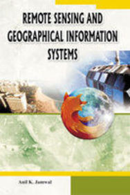
This book deals in detail about the remote sensing and geographical information
systems. Broadly speaking, remote sensing means acquiring information about a
phenomenon, object or surface while at a distance from it. This name is
attributed to recent technology in which satellites and spacecraft are used for
collecting information about the earthâÂEUR™s surface. The broad areas covered
in this book are: Aerial Photography; Basic Remote Sensing; National (Natural)
Information Managements System (NRIS); Image Interpretation; Introduction to
Digital Images; Platforms and Sensors; and Geographical Information Systems.
- ISBN-13
- 9788171391523
- Language
- English
- Binding
- Hard Bound
- Publisher
- Jnanada Prakashan (p&d)
- Publishing Date
- 2008
Remote Sensing And Gis
by Anil K. Jamwal (Author),
Jnanada Prakashan (p&d) (Publisher)
fictionfantasyyoung adultaward winning
Frequently bought together

Total for 3 items₹745₹840You save ₹95
Product Specifications
Book Summary
This book deals in detail about the remote sensing and geographical information
systems. Broadly speaking, remote sensing means acquiring information about a
phenomenon, object or surface while at a distance from it. This name is
attributed to recent technology in which satellites and spacecraft are used for
collecting information about the earthâÂEUR™s surface. The broad areas covered
in this book are: Aerial Photography; Basic Remote Sensing; National (Natural)
Information Managements System (NRIS); Image Interpretation; Introduction to
Digital Images; Platforms and Sensors; and Geographical Information Systems.
Book Specifications
- ISBN-13
- 9788171391523
- Language
- English
- Binding
- Hard Bound
- Publisher
- Jnanada Prakashan (p&d)
- Publishing Date
- 2008